This document gives some intriguing clues to Simon's early life, and would put is birthdate roughly at around the early 1790's.
"Simon King...Now in Chudleigh, born in Chawleigh, when he was about 12 went to work for Farmer Willaby for a year and then another, he then went to Shobrooke and worked for Farmer May for a year, he then threshed barley for him by the score, he then came to Chudleigh and Mr. Whiteway where he stayed 6 months, he then went to Mr. Gerry and after 9 months he married in Chudleigh."
Now, to the marriage of Simon King and Ann Parker...
Simon King and Ann Parker Marriage Banns from February 25, 1812. Chudleigh, Devon, England.
England, Devon Bishop's Transcripts, 1558-1887," database with images, FamilySearch (https://familysearch.org/ark:/61903/1:1:QGLJ-4HZV : 11 September 2019), Simon King and Ann Parker, Chudleigh, Devon, England, United Kingdom; citing Marriage, The Devon Record Office, Exeter.
The marriage entry of Simon King and Ann Parker reads: "Banns of marriage of Simon King of this parish and Ann Parker of this parish were read 19th of January, 26th January and 2nd February 1812. Marriage entry; Simon King sojourner in this parish of Chudleigh and Ann Parker of this parish were married in this parish by banns this 25th day of February in the year 1812". (information provided by MAngove. I do not have an actual copy of this information). Banns were read out on three successive Sundays in a parish church, announcing the intended marriage and giving opportunities for objections.
So, I began researching this Simon King family.
Simon and Ann (possibly) had the following children, based on birth/baptismal records and census records from Ancestry and FamilySearch...
1. Mary King b. 15 Aug. 1812 Chudleigh, Devon. She was listed as a daughter of Ann on the 1841 Census and was living with her aunt Mary Parker Jory in 1851.
"England, Devon Bishop's Transcripts, 1558-1887," database with images, FamilySearch (https://familysearch.org/ark:/61903/3:1:3QS7-L94Y-98JR?cc=2515875&wc=QZBV-MXN%3A1589444304 : 11 September 2019), 004395051 > image 289 of 292; Devon Record Office, Exeter.
2. Ann King (May) b. 14 Nov. 1814 Chudleigh, Devon. Father Simon's occupation was listed as labourer at the time of her birth. I do not have the original image.
3. Elizabeth King baptized Dec. 8 1816 in Chawleigh, Devon (possible child; baptismal records are not conclusive. She was listed on the 1841 Census and may have died by 1844).
4. Sarah King (Ruse) b. 1819 Chudleigh, Chalwleigh, Teignmouth, or Chumleigh, Devon (based on census information from 1841 to 1901. No baptismal records found. Birth year extrapolated from census records).
5. Amelia King (Rundle) b. 1821 in Chudleigh, Devon (based on census information; no baptismal records found).
6. Simon King b. 1822 or 23 Chudleigh, Devon (based on census information; no baptismal records found). Occupation: Shoemaker.
7. William King baptized Nov. 7, 1824 in either Chawleigh, Chudleigh, Stoke Damerel or Devonport, Devon, depending on which census and baptismal record you look at). I have spent considerable time trying to definitively link this William, who I know to be the father of Charles John King, to the family of Simon and Ann King originally from Chudleigh.
Marriage Record for William King and Catherine Levers Brown
"England, Devon, Parish Registers, 1538-1912," database with images, FamilySearch (https://familysearch.org/ark:/61903/3:1:939N-QW5K-K?cc=1804330&wc=M618-2P8%3A146828401 : 28 July 2021), 004634233 > image 210 of 251; from "Church of England parish registers 1538-1911," database and images, findmypast (http://www.findmypast.com : n.d.); citing images provided by FamilySearch International
William King and Catherine Levers Brown were married in the Stoke Damerel Parish Church on February 23, 1848. William was living at 7 Barrack Street and Simon King was listed as his father. Both were working as carpenters. One witness was William Giles Jory, son of Mary Parker Jory. Mary Parker was most likely the sister of Ann Parker. All these clues point to a connection between William and the family of Simon and Ann. The only discrepancy would be that by 1841 William's mother Ann was remarried to James Hill and was listed as a widower on her second marriage record. Simon was not marked as deceased on the register. I believe that he had either passed away by 1841 or was no longer in the area or involved with the family.
8. James King b. 1 March 1827 Devonport, baptized May 3 in the Princes Street Chapel (Independent) (family living on Market Lane) Devon, buried November 2, 1827, family living on Barrack Street, Devon.
England, Select Births and Christenings, 1538-1975 Ancestry
"England, Devon, Parish Registers, 1538-1912," database with images, FamilySearch (https://familysearch.org/ark:/61903/3:1:939N-QW9H-2?cc=1804330&wc=M618-KM9%3A146809301 : 20 May 2014), 004634217 > image 336 of 377; from "Church of England parish registers 1538-1911," database and images, findmypast (http://www.findmypast.com : n.d.); citing images provided by FamilySearch International.
9. John King b. 1828 Devonport, Devon. Baptized in the Princes Street Chapel (Independent) on October 31, 1828. Simon's occupation was Porter.
England & Wales, Non-Conformist and Non-Parochial Registers, 1567-1936 Ancestry
10. Harriet King b. 1834. She appeared on the 1841 Census, and did not appear on any census after that. No baptismal records found. She may or may not have been a daughter of Ann King.
11. Matilda King (Blowey) baptized on August 3, 1835 in the Parish of Stoke Damerel, Devon. No address was recorded.
"England, Devon, Parish Registers, 1538-1912," database with images, FamilySearch (https://familysearch.org/ark:/61903/3:1:939N-Q7S9-Z7?cc=1804330&wc=M618-V2Q%3A146809201 : 20 May 2014), 004634089 > image 275 of 306; from "Church of England parish registers 1538-1911," database and images, findmypast (http://www.findmypast.com : n.d.); citing images provided by FamilySearch International.
****************************************************
The reason for moving to the parish of Stoke Damerel (Devonport) is unknown, but Simon and Ann King moved sometime between 1824 and 1827 and had three or four more children together before the 1841 Census. There are some discrepancies as to the exact date of death for Simon (was it between 1838 and 1841?) Or was he still alive when daughter Ann was married in 1839, or when son Simon was married in 1844 or when son William was married in 1848, as he was listed on all three marriage registers with no notation that he was deceased. What exactly was his occupation at the time of his death? William's marriage records stated that his father Simon was a carpenter. Ann remarried in March of 1841 before the 1841 Census was taken. She was enumerated with James Hill on the 1841 Census, living on Barrack Street.
Chudleigh is a mere 35 plus miles from Devonport, but must have seemed far away in the early 1800's. Moving from a primarily rural farming and wool production area to a larger port city must have been quite a change for the family, also. Simon was a husbandman (farmer) and laborer, but his son Simon became a cordwainer (a boot/shoe maker) by 1844 and William's occupation by 1848 was described as carpenter. It is not known what type of carpentry he did; it could have been naval or as a commercial tradesman. Perhaps both father Simon and son William had begun working as carpenters together. Three of their daughters married men with good trades (shoemaker, stonemason and sailor in the Royal Navy). Perhaps economically it made more sense for the family to move to this location where Simon and Ann's children could improve their lives.
What is known about this family group after their relocation to Devonport comes from Baptismal records from 1827 and 1828, marriage registrations from 1839, 1841 and 1844, and Census records from 1841 up through 1901. While doing more in depth research, it soon became clear to me that finding exactly where the Kings lived in the Stoke Damerel parish was going to be difficult. Many street names are no longer found on modern maps. Why?
The "Bomb Book". This document recorded where and when various devices were dropped on Plymouth by the Germans from 1940-1944.
From the Plymouth "Bomb Book" (enlarged). Notice the damage level for Plymouth and Devonport.
https://www.theboxplymouth.com/blog/history/blitz-80-the-bomb-book from April, 2021
Unfortunately, the Royal Dockyards were targeted from 1940-1944 in numerous and devastating bombing raids; much of the area that the Kings lived and worked in was obliterated along with most of Devonport and Plymouth's shopping districts and adjacent neighborhoods. WWII blitz raids killed 1,200 citizens, injured 5,000 people and destroyed or damaged 23,000 homes. The Devonport/Plymouth area looks very different today than it did before 1940. Many streets were altered (shortened or renamed) or were done away with all together during reconstruction. Many of the terraced row houses the Kings lived in were replaced with new, modern housing after the war.
The Bomb Book is housed at "The Box"...Plymouth's museum, art gallery and archive. Formally known as the Plymouth City Museum and Art Gallery it reopened in 2020 as The Box.
From The Plymouth Bomb Book. The area circled in green is the area of Devonport that the Kings lived in before the turn of the century. Red dots denote where devices hit in this particular raid.
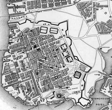
Luckily, old maps and photographs of the area in the 19th Century give us a sense of location and place. The National Library of Scotland has a wonderful website with many older maps of the area available (maps.nls.uk); I added it to the Links section on the left if you want more information. I used their maps as well as maps from other research sites to help with location identification. It also helps to have a bit of history of the area and explanation of place names to help interpret census information.
Plan of Plymouth Dock, 1811 from https://someolddevonchurches.files.wordpress.com/2016/09/plymouth-dock-1811.jpg
Devonport was formerly named Plymouth Dock, or just Dock. Robert Waters was given a contract to build a dock in 1690 by the Admiralty, and Plymouth Dock grew around it as a small settlement to house workers employed by the Naval base being built there. Its population continued to grow. It was given the name Devonport in 1823 and became part of the city of Plymouth in 1928.
Stoke Damerel was one of the ancient parishes in Devon. The village of Stoke is located a little ways inland, but the parish included stretches of the coast west of Plymouth and north of Devonport. The Kings settled in Devonport in the general neighborhood where Market Place is located on the above map. They lived in the parish of Stoke Damerel.
This map is from 1901, but gives a good idea of where Devonport is in relation to Plymouth. Mt. Edgcumbe is a part of Cornwall which is located right across the River Tamar. The area that the Kings lived in is circled in blue.
So, walking through the records, we can see where this King family and their children lived and worked.
Again, this is the birth and baptismal record for James King, born March 1, 1827 to Simon and Ann King. It was registered in the parish of Stoke Damerel, and the family lived on Market Lane. James was baptized in the Princes Street Chapel (Independent). This is the earliest record I could find for this family in Devonport. Simon was working as a porter at the time. Unfortunately, James died and was buried in October of 1827, after his family had moved to Barrack Street. His brother John was born in 1828 and was baptized in the same chapel as James. John died in 1838.
"Unenviably Plymouth was in the top twenty towns for mortality" during the Victorian period. The town of Plymouth was ranked seventh in national unhealthiness in the 1840's and experienced intermittent outbreaks of cholera and typhus. https://plymhistoryfest.files.wordpress.com/2020/05/filthy-plymouth.pdf
Devonport Map, before 1800, showing the Anglican Church of St. Aubyn on Chapel Street. This church survived the blitz, and is now the Devonport Library and Cafe.
According to olddevonport. uk, Princes Street, sometimes printed on maps as Princess Street, was one of the principal business streets in town and ran parallel to Fore Street. The Princes Street Congregational Chapel was built in 1801 and was located somewhere in this vicinity. The King family lived on Market Lane and Barrack Street which were also in this vicinity, and I thought the exact location of Market Lane was lost. I enlisted help from the Old and New Pictures of Devonport, Mountwise and Other Parts of Plymouth Facebook group and the general consensus was that Market Lane was most likely located where Sydney Street is marked on this later map (below) from 1890-1920. The large Devonport Market was located at the junctions of Catherine Street, Market Street, Tavistock street, Barrack Street, Cumberland Street and Duke Street. It would have been very accessible to the King family.

Map of Devonport from 1890-1920. The historic market site has now become Market Hall housing a technology hub and immersive reality dome. realideas.org
This is a marriage registry for Ann King and William May dated October 13, 1839. They signed with their marks. William May was a shoemaker at the time of their marriage. I do not know if this May was related to the May family in Shobrooke. They were both living on Southside Street, Plymouth. They were married in the Parish Church of St. Andrew in Plymouth (Anglican). Ann's father Simon King's occupation was listed as farmer.
This church was heavily damaged during WWII and has since been re-roofed and restored.
This is a marriage registry for Ann King and James Hill dated March 10, 1841. Interestingly, both Ann and James were living on Bath Street and were married in the Parish Church at St. Andrew's in Plymouth (Anglican). Bath Street was a short distance from Southside Street where Ann King's daughter Ann lived in 1839 before her marriage. Ann Parker King's father was James Parker. Ann was 47 at the time of her remarriage; was her father still living? The marriage was witnessed by Mary Parker Jory, Ann's sister. James Hill was around 55 years of age.
"England, Devon, Parish Registers, 1538-1912," database with images, FamilySearch (https://familysearch.org/ark:/61903/3:1:939N-QW98-JG?cc=1804330&wc=M618-BNL%3A146885301 : 20 May 2014), 004634333 > image 146 of 252; from "Church of England parish registers 1538-1911," database and images, findmypast (http://www.findmypast.com : n.d.); citing images provided by FamilySearch International.
The 1841 Census Devonport/Parish of Stoke Damerel
**The 1841 Census was the first English census that produced useful information for genealogists. Occupants were recorded on the night of Sunday, June 6, 1841. Household occupants were to fill out the census form a few days prior which was then collected by the enumerator on June 7th. That information was then transcribed into the enumerator's schedule. The result was that exact ages were not always recorded, or the relationship between household members or exact places of birth. Since the census was taken in June, many family members may have been working away from home if they were farmers. The 1841 census was a little confusing for this family, but I believe I have worked out family members and their relationships.
The census of 1841 listed Ann Parker King as Ann Hill, as she married James Hill in the spring of 1841. The family had moved back to Devonport from Plymouth. She was living on Barrack Street (no number but most likely number 7) with her husband James listed as head of family (occupation: Pensioner). Listed as part of the household were Ann's children Mary King, Elizabeth King, Simon King (aged 18), Matilda King, Amelia and Harriet as well as her daughter Ann May. Husband William May was not enumerated so was not home at the time. Harriet and Amelia were listed under Ann May and appear in transcriptions as Harriet May and Amelia May (daughters of Ann May). Because of age discrepancies these two girls must have been daughters of Ann. Daughters Mary and Elizabeth (ages 25, 20) listed their occupations as "laundry", so were working to help support the family. Interestingly, son William was not enumerated. He would have been 17 years old as of this census. Where could he have been? I was unable to find him in any 1841 census. Perhaps he was working or serving an apprenticeship somewhere in the area or out of the area. Daughter Sarah and her husband Richard Ruse were living in the parish of Plymstock, also a part of Plymouth, but across the River Plym. Richard was a stonemason.
Sometime between 1841 and 1844 Simon King (Jr.) met and then married Ann Bumpass. William Jory was a witness to their marriage. Simon King was listed as father, and was working as a labourer. He was not listed as deceased.
The marriage registration for Simon King (Jr.) and Ann Bumpass. They were married June 25, 1844 in the Parish Church of Stoke Damerel (Church of England). Simon's occupation was "cordwainer" (shoe and boot maker). His father Simon's occupation was labourer.
The marriage registration for William King and Catherine Levers Brown February 23, 1848. They were also married in the Parish Church of Stoke Damerel. Catherine's father Samuel Brown was a carpenter in the Navy. He was listed on the 1851 Census, but by 1861 wife Elizabeth was a widow. He was alive at the time of this marriage.
Somewhere between 1841 and 1848 William began learning the trade of carpentry, met and then married Catherine Levers Brown in 1848. William Giles Jory was a witness to his marriage. His father Simon King's occupation was listed as carpenter. Again, he was not listed as being deceased. Was his occupation also wrong? He was primarily known for working as a farmer or laborer. This remains a mystery.
File:Stoke Damerel Church in winter - geograph.org.uk - 1111563.jpg |
This church dates from the 15th century, survived WWII and continues to serve the residents of Devonport as a parish church.
The 1851 Census Devonport/Parish of Stoke Damerel
**The 1851 Census was taken on the night of Sunday, March 30, 1851. It also recorded the county and parish or town of birth.
The census of 1851 lists Simon King (Jr.)as head of family, living at number 7 Barrack Street with his family.
The census listed Simon and Ann as well as their young daughter. Simon was a shoemaker. Also living at number 7 Barrack Street were:
*James Hill and Ann Parker/King/Hill along with Matilda King
*William May (laborer), Ann and their three children (also listed was a John May/laborer listed as a 'visitor' who may have been a brother or close relative of William)
*Richard Ruse (stonemason), Sarah and their two children
*John Rundle (laborer) and Amelia.
18 total family members lived together.
Besides the King family there were four other families living at number 7 Barrack Street. According to localhistories.org there was a serious shortage of housing in Plymouth at this time and overcrowding was a problem. In 1850 the average number of people living in each house was 10. There had been a large outbreak of cholera in 1849 that was most likely caused by population density and poor sanitation. Close proximity of cess pits and privies to dwellings, and the pollution caused by livestock made for lives of squalor, misery and disease. Proper systems of drains and sewers were not built until the late 1800's, meaning that sewage flowed through the streets and into the harbor. plymhistoryfest.files.wordpress.com. Daughter Elizabeth may have died in January of 1844 from causes unknown, but unhealthy living conditions could certainly have contributed. It is hard to imagine what the living arrangements and conditions were really like for these families at number 7 Barrack Street in 1851.
The type of unit that was enumerated was probably the typical terraced, three or four storied building, possibly with shops on the street level. It is hard to say how big number 7 was, but it may have looked similar to this section of Marlborough Street which was just a few blocks away. This picture was taken around the turn of the century, and things looked a little cleaner and tidier than they may have been in the 1850's.
https://www.devonportonline.co.uk/millennium_devonport/visiting/streets/marlborough-street/marlborough_street.aspx
By 1851 eldest daughter Mary King was living at number 20 Catherine Street with the family of Mary Jory who was a widow and whose occupation was 'china dealer'. Along with Mary Jory was her daughter Matilda Brown and Matilda's son Albert. Mary Parker Jory was most likely the sister of Ann Parker. The Jory family were glass and china dealers in Devonport. Before his death, husband Giles Jory was an earthenware dealer. Mary Jory sold her wares at the Devonport Market in 1852, as did her son James who was a glass cutter (olddevonportuk). There may be a Brown Cornwall connection with Matilda's husband Thomas Nicholls Brown, but I need to do some more research there.
By 1851 William King (my 3 times great grandfather) was living at number 10 Charlottes Row and was a carpenter by trade. He was married to Catherine Levers Brown and they had one son, William Jr. Right next door to the Kings were Samuel Brown and Elizabeth Levers Brown, Catherine's parents. Samuel Brown was a pensioner in the Royal Navy. Charlottes Row was near Charlotte Street, in Morice Town. Morice Town was built as housing for workers in the Dock Yard, and named after Sir William Morice who owned the land.
Shown above is an 1860 Map of Devonport and Morice town. Highlighted in yellow are Barrack Street, Catherine Street and their proximity to Charlotte Terrace and Charlotte Street at the top of the map. I went on the assumption that Charlotte Row would be somewhere in this neighborhood, and would be a small side street. After a little more research, I did find the exact location of the street on a more up to date map.
From The Western Morning News Plymouth, Devon 14 June, 1949. The newspaper article mentioned street amendments taking place in this neighborhood in 1949. Charlotte Row was a small side street parallel to Charlotte Street.
So, William and Catherine King lived not too far from William's brother Simon, his mother Ann and sisters Sarah, Ann and Amelia on Barrack Street. The empty space between the two neighborhoods would become Devonport Park sometime in the 1850's.
The 1861 Census Devonport/Parish of Stoke Damerel
By this time the families had spread out a little more from their Barrack Street address of 1851. The housing situation and family economics may have improved enough that each family could have their own living space.
*Ann Parker King/Hill is not found on any census after 1851. Her death date is unknown.
*I could not find any information on Mary King after the 1851 Census.
*William May and Ann King May and their three children lived at number 17 Pond Lane.
*Richard Ruse, wife Sarah King Ruse and their three children lived at number 3 Ordnance Street.
*Amelia King Rundle passed away in 1855, possibly after admission to the County Lunacy Asylum.
*Simon King (Jr.) lived at number 9 Cross Street with his family.
*William King (my third great grandfather) was still living at number 10 Charlotte Row, with Catherine, William, Samuel and daughters Susan and Laura. Elizabeth Brown, Catherine's mother, lived with the family also.
*Matilda King Blowey was living as head of household, tailoress, at 51 Grandby Street with her two sons. Her husband was a sailor, and may have been at sea during this time.
*The Jory family was still living at 20 Catherine Street. Mary was 73 years old, and still worked as a glass and china dealer. Her son James was a glass cutter, and lived at the same address. Son William Giles Jory, who was listed as a witness on the marriage register of both Simon and William King, also lived at 20 Catherine Street. He subsequently worked in the Royal Navy as a ship's steward and then a licensed victualer. His Naval records show that he served aboard ships named Atholl, Amethyst, Beagle, Implacable, Royal Adelaide, Prince Regent and Royal Albert. He passed away in 1898.

Pond Lane may have been off Cherry Garden Street. There was indeed a pond there at one time. Cross Street was located between Cherry Garden and Barrack Streets (highlighted in yellow). Identifying Pond Lane and Cross Streets was difficult, and I had some wonderful help from the Old and New Pictures of Devonport, Mountwise and Other Parts of Plymouth FaceBook members in locating these areas. Not pictured in this map is Charlotte Row in Morice Town.
The 1871 Census Devonport, Devon and Saltash, Cornwall
*Ann King May, along with her son and his family lived at number 3 Ordnance Street with Richard and Sarah Ruse and their four children.
*Simon King (Jr.) , wife Ann, and three sons had moved to number 32 Cherry Garden Street.
*William King and wife Catherine had moved to number 90 Fore Street in Saltash, Cornwall, with their children. This is the first census that my great great grandfather, Charles King, appeared in. He was seven years old. Saltash was just across the Tamar River. William King worked as a carpenter and his wife Catherine worked as a shop keeper.
*Matilda King Blowey was now living at number 5 Mill Pleasant in the Parish of Stoke Damerel with her two sons. She listed herself as the wife of a sailor, and her husband in not enumerated on this census as well.
*Mary Parker Jorey may have passed away in 1869.
The area that Mill Pleasant used to be located was just outside the neighborhoods that the rest of the King families lived. It was an extension of Fore Street, which eventually turned into Paradise Road and led to the Stoke Damerel Church.
The 1881 Census Devonport/Saltash/West Ham
*Ann King May passed away in 1876.
*Sarah King Ruse, widower, lived at number 3 Ordnance with a daughter and grandson.
*The widow of Simon King, Ann Bumpass King, lived at number 16 Cherry Garden Street and was working as a bookbinder or bootbinder. She was 57 years old. It appears that the numbers on Cherry Garden Street had changed from the previous census, and number 16 may have been the same residence as in 1871. She passed away in 1886.
*William King, Catherine Levers King, and their daughter Laura and son John (Charles John King, my great great grandfather) were living at number 15 Fore Street in Saltash, Cornwall. William was a carpenter/joiner and Charles was a carpenter's apprentice. He was 17 years old.
*Matilda King Blowey had moved to West Ham where her husband was now a Royal Navy pensioner. She passed away in 1908.
The 1891 Census Devonport/Saltash
*Sarah King Ruse lived at number 9 Morice Street with several Ruse family members. Morice Street was located next to Morice Square, right off of Grandby Street and very near Ordnance Street. She passed away in 1901.
*By 1891 William King had moved to St. Austell, Cornwall, to live with his daughter Laura. He was still working as a carpenter when he died in 1901. Charles John King was living in the same neighborhood with his wife Anna Levers King and my great grandmother, Emma Lavinia King.
The 1901 Census Devonport, Devon
The daughter of Simon King and Ann Bumpass, Elizabeth Ann King Michell (Mitchell) was living at 47 Cannon Street with her son Walter, and brothers Charles and William King. Her son William King Michell proved a will for an Elizabeth King (widow) in 1869 who died at 3 Ordnance Street. I'm not sure which King this Elizabeth married, but there must have been a close connection there. That is the same residence where Sarah King Ruse lived earlier. There were May family members at that address also. Cannon Street was located at the top of Queen Street.
Given this analysis of records, I do believe that my great great great grandfather William King was the son of Simon King and Ann Parker. The King family moved to Devonport from Chudleigh, and tended to stay in the same neighborhoods and with the same family groups. Some addresses remained the same through several generations. They also passed the same first names down through succeeding generations, and used King as a middle name in some families. Connections with the Jory family also give interesting clues. However, the fate of Simon King senior may never be known. Until more records are found or transcribed, we will never know the rest of his story.
*****************************************************
This was taken from devonportonline.co.uk and gives a more concise description of Plymouth Dock than I can. I believe this description of where the King family lived in the early to late 1800's helped shape the next generation of Kings, namely that of my great great grandfather Charles John King and his brothers. They grew up to serve in the Royal Army and Navy. I will continue with the family of William King and Catherine Levers Brown in the next post.....
Plymouth Dock - A Garrison Town
Overview
Typically, Devonport/Plymouth Dock is considered first and foremost a naval town - both by our own local residents, and by non-residents. While that remains true, Devonport was and still is a naval district and dockyard area, there is a period in our history when we were also recognised as one of England's major garrison towns. And that period is not too far in our past.......
This 1850 map, below, presents the situation very clearly. On one side, to the west, we were hemmed in by the Admiralty; they had claimed almost the entire river frontage for the dockyard and navy. On the north and east we were surrounded by the Army, with a series of barracks encircling the land side of Devonport. The thick black line outside of the barracks, surrounding the town, was the garrison wall - in some places 20 foot high, in other places 30 maybe 40 foot high. Residents called this wall 'The Lines'. The Lines were built with one purpose - as defensive fortifications surrounding Devonport to protect the dockyard from attack. Abutting the outside of the garrison wall was a dry moat/ditch. Finally there was the glacis - a wide band of grassland arcing around the entire town - shown on the map as plain white space with footpaths across it.
Devonport - extracted from the Map of Plymouth, Devonport and Stonehouse engraved by Rapkin, published by Tallis c1850
Although residents of the period were virtually hemmed in, (for many years the only land exit was via drawbridge) I prefer to think of them as being protected. I suspect that the isolation created by both the garrison wall, and by the green arc beyond that, nurtured a territorial culture that exists to this day. Devonportees, of all residents within Plymouth, have the strongest sense of place.
For 140 years the townsfolk of central Devonport lived inside the walls - and if you were born inside the garrison, 'within the Lines', you were a true Devonportee. As the town grew and expanded with the new build of Morice-Town, Stoke, etc., then of course many Devonport people were born 'without the Lines' - this adding to Devonportees' sense of place, whether you were born 'Within or Without'.
A Colourful Scene
Throughout the 18th and 19th centuries Plymouth Dock was crowded with soldiers - with Infantry (Marlborough, Granby and Cumberland barracks), Royal Engineers and Artificers (Frederick Square barracks), Royal Artillery (Legonier Square barracks), and in Mount Wise barracks were the Royal Engineers' workshops. Around 1854 began the build of Raglan barracks, replacing Frederick, Legonier and Cumberland barracks. Raglan held 2000 men and their officers, that is, two full regiments. The garrison church in nearby Cumberland Road could seat 1000 men. The town was indeed crowded.
Can't you just imagine the colour and spectacle of life in Devonport then? Unlike today, uniforms then were worn both in and out of barracks. Also, uniforms and military costumes during those centuries were more flamboyant and colourful than now. The grandeur of dress was important to each regiment - little touches here, more feathers in the hat maybe, more buttons, badges or gold braid... Regiments would scrutinise each others’ uniforms minutely. Myerly 1996 commented ** When an officer appeared one Sunday evening (c1804?) at the Plymouth Dock promenade wearing hussar boots with a silk tassel hanging from the pointed brim, Captain Mercer wrote: "I shall not in a hurry forget the sensation caused ... ‘Oh, the puppy!’ was heard on all sides. ‘If he has not silk tassels to his boots! Only think! Silk tassels on boots!’* Such pride in their outfits enhanced the Esprit de corps of a company or regiment. It was all part of the spectacle, an ever changing spectacle, since regiments moved in and out of Devonport constantly - some stayed only months, some years, some returned regularly for long stays, such as the Devon & Cornwall Light Infantry. There were Regiments of Foot, Rifle Regiments, Volunteer regiments, the Plymouth Dock regiment, the Plymouth Dock Cavalry, the list goes on. The town was alive with colour, mostly red.
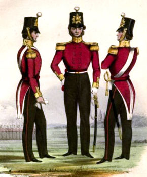
The 46th Foot Regiment c1850


.png)
.png)
.png)